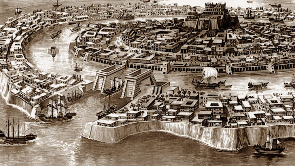
Mainstream archaeology describes ancient Sumeria (Mesopotamia, modern-day Iraq) as the first emergence of civilization – around the year 4500 B.C. However, more recent discoveries like the buried structures at Göbekli Tepe (~9500 B.C.) suggest a much older complex society that was forgotten.
If a global seafaring civilization existed long ago, it would explain why step-pyramids appear in South America and other regions far from the pyramids in Egypt. Several personalities have advanced the theory of there being a lost chapter in human history, here are some highlights of their contributions:
- Geological evidence suggests a major comet impact 12,900 years ago that caused global flooding
- Water erosion in a vertical pattern at the base of the Sphinx points to heavy rainfall (and not wind/sand erosion) that would have only been present when the climate in Egypt was much different – around 7,000 B.C.
- Everyone loves the legend of Atlantis – Plato described the features and characteristics of the “Naval Empire’s” capital city, and many of the descriptions match the “Eye of the Sahara.” Satellite imagery gives that region the appearance of having been swept away
- There are several megalithic structures around the world using large multi-ton boulders that fit perfectly together. Later occupants of these structures attempt to rebuild or repair them, but use more basic masonry techniques. Yet these later occupants are credited as the original builders.
- The famous Labyrinth reported by the Greek historian Herodotus was supposedly built around 5,000 years ago. But it’s megalithic construction is considered even more impressive than the pyramids, and could be much older

Randall Carlson
Randall Carlson, a geologist, researcher, and podcaster, is a prominent proponent of the Younger Dryas Impact Hypothesis (YDIH). In his podcasts (e.g., Kosmographia series), lectures, and discussions (often with Graham Hancock on Joe Rogan), he argues that a catastrophic cosmic event around 12,900 years ago triggered the abrupt Younger Dryas period—a sudden 1,200-year return to ice-age conditions after post-glacial warming.
Key points from Carlson’s view:
- A fragmenting comet (possibly from the Taurid meteor stream) entered Earth’s atmosphere, causing multiple airbursts and/or surface impacts primarily over the North American Laurentide Ice Sheet (with effects elsewhere).
- The impacts melted massive volumes of ice rapidly, injecting water vapor and soot into the atmosphere, causing global cooling (“impact winter”).
- This released enormous megafloods (evident in features like the Channeled Scablands, which Carlson links to catastrophic outflow from glacial lakes like Agassiz and Hind).
- Evidence includes:
- A widespread “black mat” layer with nanodiamonds, microspherules, platinum peaks, and high-temperature meltglass.
- Sudden megafauna extinctions (e.g., mammoths).
- Disappearance of Clovis culture sites.
- Geomorphic scars from hyper-velocity floods.
- Carlson frames this as part of cyclical cosmic catastrophes, emphasizing interdisciplinary evidence (geology, astronomy, archaeology) and criticizes mainstream resistance to paradigm-shifting ideas.
He highlights ongoing research supporting the hypothesis (e.g., sites in South America, Greenland, Murray Springs) and argues it explains unresolved anomalies better than gradualist models like Atlantic circulation shutdown.
Graham Hancock
Graham Hancock, a British journalist and author, is best known for challenging mainstream archaeology with the idea that human history is far older and more advanced than we think.
Key Elements of Hancock’s Theories:
- The Lost Civilization: Around 12,000–13,000 years ago (end of the Ice Age), a highly sophisticated global society existed with advanced knowledge in astronomy, mathematics, architecture, and navigation. This civilization was technologically and culturally superior to what followed.
- The Cataclysm: This advanced society was largely destroyed by a massive global disaster—likely comet impacts or fragments triggering the Younger Dryas period (a sudden cooling event ~12,900 years ago). This caused rapid sea-level rise, megafloods, and an “impact winter,” wiping out most evidence (much of it now underwater).
- Survivors as Teachers: A few survivors escaped and traveled the world, acting as “civilizers” or “magicians.” They shared knowledge with hunter-gatherers, kickstarting later civilizations like ancient Egypt (pyramids, Sphinx), Mesoamerica (Mayans, Olmecs), Sumer, and sites in Indonesia (e.g., Gunung Padang) or the Americas (mound builders, Serpent Mound).
- Evidence Hancock Cites:
- Ancient monuments aligned with stars or much older than official dates (e.g., Sphinx water erosion suggesting pre-10,000 B.C. origins).
- Similar myths worldwide (flood stories, bearded gods like Viracocha or Quetzalcoatl).
- Anomalous maps (e.g., Piri Reis map showing Antarctica ice-free).
- Archaeological sites in the Americas predating Clovis culture (e.g., footprints over 20,000 years old, potential 130,000-year evidence).
- Connections to Plato’s Atlantis legend.
- Criticism of Mainstream Views: Hancock argues archaeologists are dogmatic, ignoring evidence due to rigid timelines, and suppressing alternative ideas. He sees himself as an outsider asking questions academia won’t.
Jimmy Corsetti
Jimmy Corsetti, known online as Bright Insight, is a researcher who has popularized the idea since around 2017 that the Richat Structure (also called the Eye of the Sahara), a massive eroded geological dome in Mauritania, northwest Africa, is the true location of the lost city of Atlantis as described by Plato in Timaeus and Critias. Corsetti argues that this 23-40 km (14-25 mile) wide formation aligns remarkably with Plato’s account of a advanced island civilization destroyed by a cataclysm around 11,600 years ago, challenging mainstream views that dismiss Atlantis as myth or place it elsewhere (e.g., the Mediterranean or Azores).
Key Matches to Plato’s Description
Plato portrayed Atlantis as a powerful naval empire beyond the “Pillars of Hercules” (Strait of Gibraltar) with:
- Concentric rings: Alternating circular moats/canals of water and land rings, centered on a royal palace and acropolis atop a low mountain.
- Size and layout: A vast plain with a central harbor, supporting a population of over a million in a highly engineered city.
- Destruction: Sunk by earthquakes and floods in a single day and night.
Corsetti claims the Richat’s bullseye-like anticlines (ridged rings) match these exactly—three main land rings separated by what were once water channels, with the central “acropolis” as a 400-meter hill. Its inland position (250 miles from the Atlantic) and elevation (400 meters/1,300 feet above sea level) explain submersion via tsunamis rather than rising seas.
Evidence Presented by Corsetti
Corsetti draws from satellite imagery, geology, ancient texts, and paleoclimatology, emphasizing how the structure’s features defy its official classification as a 100-million-year-old volcanic uplift eroded by wind.
- Geological and Hydrological Features:
- Erosion patterns: Striations and ripple marks on ridges indicate massive water flow (e.g., from flash floods or tsunamis), not just wind/sand. Salt deposits and evaporites suggest former brackish lagoons or sea incursion.
- Rings and infrastructure: The outer ring aligns with a possible harbor; inner ridges could hold walls or buildings. Blue hues in satellite photos hint at subsurface water or minerals from ancient inundation.
- Scale: Large enough for Plato’s metropolis, with nearby chotts (salt flats) as remnants of drained lakes.
- Historical and Cartographic Clues:
- Ancient maps: A 2,500-year-old Greco-Roman map (possibly by Herodotus-influenced sources) labels “Atlantes” (people of Atlantis) precisely at the Richat’s location in northwest Africa. Corsetti cites this as evidence the site was known to ancients as a flooded realm.
- Plato’s sources: The story came via Egyptian priests to Solon; Corsetti argues it refers to a real Saharan event, not allegory.
- Paleoclimatic and Cataclysmic Context:
- Green Sahara: Around 12,000–20,000 years ago, the African Humid Period made the Sahara a fertile savanna with rivers, lakes (e.g., Mega-Lake Chad), and human settlements—ideal for an advanced culture.
- Younger Dryas Impact: Corsetti links destruction to comet fragments exploding ~12,800 years ago (per the Younger Dryas Impact Hypothesis), causing mega-tsunamis, wildfires, and a 1,200-year cold snap. Evidence includes “nuclear glass” (trinitite-like impact melt) in regional sediments and the site’s sudden aridification.
Ben van Kerkwyk (UnchartedX)
Ben van Kerkwyk, creator of the YouTube channel UnchartedX, researched the ancient Egyptian “Labyrinth” at Hawara (near the Fayum Oasis, south of Giza). This massive, multi-level underground complex—described by ancient historians like Herodotus (5th century BCE), Strabo, and Pliny the Elder as rivaling or surpassing the pyramids in scale and grandeur—has long been “lost” or dismissed as exaggerated myth. Van Kerkwyk argues it’s real, buried and flooded, and modern geophysical scans (from expeditions like Mataha in 2008 and Merlin Burrows in 2023–2024) confirm its existence, revealing anomalies that suggest advanced ancient engineering—or even non-human artifacts. The discussions blend archaeology, geology, and speculation on lost civilizations, tying into broader theories of pre-dynastic knowledge (e.g., precision stonework predating known Egyptian tech).
Van Kerkwyk bases his claims on historical texts, expedition reports, and satellite/radar data, asserting the labyrinth was built at least ~4,500–5,000 years ago (Middle Kingdom, under Pharaoh Amenemhat III) but is possibly much older. He calls it “the greatest ancient structure you’ve never heard of” due to suppression or flooding.
- Historical Descriptions:
- Herodotus: A vast roofed complex with 3,000 rooms (1,500 above/1,500 below ground), courtyards, and columns; “greater than all Greek works combined” in labor.
- Strabo (1st century BCE): Compared to the pyramids; entered via a 100-yard-wide courtyard.
- Pliny/Diodorus: Multi-level (up to 4 floors), with hieroglyphic walls, labyrinthine passages, and a central “acropolis” or atrium.
- Van Kerkwyk: These align with Hawara’s pyramid temple (excavated by Flinders Petrie in 1888–89, who found partial mudbrick walls but stopped due to flooding). He argues Petrie missed the full scale because it’s subterranean and waterlogged.
- Modern Evidence from Scans:
- Mataha Expedition (2008): Joint Egyptian-Japanese project using ground-penetrating radar (GPR) and electrical resistivity tomography (ERT). Confirmed a massive structure starting ~9–10m below surface (below modern water table at ~5m), spanning ~150m x 150m in scanned sections—part of a larger ~1km x 800m complex. Features: Multi-level chambers, corridors, and voids; high-resistivity zones suggesting stone/metal.
- Merlin Burrows (2023–2024): Synthetic aperture radar (SAR) from satellites detected deeper anomalies: Dry chambers below ~30m, flooded upper levels, and a 40m-long, 5–6m-wide metallic, tic-tac-shaped object at 60–70m depth in the central atrium. Described as non-magnetic, non-stone/wood—possibly a “metallic craft” or advanced artifact. Van Kerkwyk: “It’s unclassifiable; looks engineered, not natural.”
- Challenges: Site flooded (Nile irrigation); Egyptian authorities restrict digs due to groundwater and preservation concerns. Reports were “buried” until leaked/shared in 2024–2025.

Leave a Reply